560/665
)
)
)
)
, Bow, Balfour and Scott Duncan. Also marked are a couple of peaks that we climbed.")
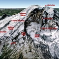
Google Earth image of the Wapta and Waputik icefields. The traverse starts at Peyto Lake on the Icefields Parkway and ends at Wapta Lodge on the Trans-Canada Highway . There are four huts en route – Peyto (Whyte), Bow, Balfour and Scott Duncan. Also marked are a couple of peaks that we climbed.
- Created on
- Monday 8 April 2013
- Posted on
- Monday 8 April 2013
- Albums
- Visits
- 5187